
Find Plano Streets by Address
A Plano street search begins with the physical, or situs, address. Enter the street number and street name in the Collin County Central Appraisal District property search. If a full street form fails, CCAD advises simplifying it, and the older interface treats the number, street name, and suffix separately. Save the Property ID, Geographic ID, subdivision, lot or block, and legal description. Those details are more reliable bridges than a name alone when the next record uses a different address style.
Use the result as a parcel trail, not as a roster. The card may show the owner, mailing address, situs address, value, exemption information, tax year, and inspection details. A mailing address can be a post office box, agent, trust, business, or old correspondence address. It does not establish that a person is present at the parcel. The address-by-address method gains strength by comparing separate records and retaining the limits of each one.
- Search CCAD by address and record the parcel identifiers, legal description, and situs address exactly as displayed.
- Open the parcel in CCAD or Plano GIS, then inspect the map, subdivision, and adjoining parcel shapes one at a time.
- Use the legal description or party name in the Collin County Clerk land-record index to locate a recorded instrument.
- For an identified person only, use Texas voter resources as a limited registration check rather than trying to create a street-wide list.
- For an older address, compare the numerical section of a verified Plano directory with the printed street name and edition date.
Note: Record the date searched and each parcel identifier, since online property information is updated nightly and older files can require a manual route.
Plano Street Directory CCAD Fields
CCAD is the practical address-to-parcel starting point for an address lookup. Its current search provides By Owner and Advanced paths. A name can be entered in last-name-first-name form, but an address search can avoid many same-name problems. The legacy search also exposes City, School District, suffix, block, tract or lot, account status, and sort controls. Current availability can change, so treat the live form as controlling.
| CCAD field | Use on a street search | Format or caution |
|---|---|---|
| Street Number | Starts an address query | Optional numeric field |
| Street Name | Locates the named road | Try without a suffix if needed |
| Property ID | Returns to the same parcel | Numeric identifier |
| Geographic ID | Links map and property context | May accept a form such as R352400A00301 |
| Subdivision and Legal Description | Bridges to plats and deeds | Exact or partial search routes are available |
| Tax Year and Property Type | Narrows appraisal records | Options are controlled by the live portal |
CCAD says its legal descriptions and acreage are for appraisal purposes and should be checked for legal purposes. That warning matters when a street has a corner parcel, a replat, or an older address form. Use the appraisal entry to find the right land description, then confirm it in the recorded document and plat rather than treating the parcel card as the last word.
Map a Plano Street Parcel
The CCAD Interactive Map and Plano GIS services provide the spatial part of the address trail. Map layers can establish parcel geometry, a residential subdivision, and municipal-boundary context. Select the subject parcel, note its identifier and lot lines, then inspect neighboring parcels one at a time. A corner parcel can have a situs address on a different road, so the polygon and legal description matter more than a quick visual reading.
Plano's public municipal-boundary service identifies a polygon whose display field is NAME, while the residential subdivision layer identifies subdivision geography. Neither is a list of people. Viewer controls and layers can change in dynamic map sessions, and the exact live set of select, identify, measure, or query controls was not captured in the research. Check the active viewer before relying on an option that may not be present.
- Parcel
- A mapped piece of land with an appraisal or geographic identifier.
- Situs address
- The physical address used to locate the parcel, distinct from an owner's mailing address.
- Plat
- A recorded subdivision map that can show lots, blocks, easements, and the legal layout.
- Criss-cross directory
- A historical address-order directory section that can be read from a number and street back to printed entries.
Note: A map supports parcel context and adjacency, but it does not identify every person connected with an address.
Bridge Plano Parcels to Deeds
Once CCAD supplies a legal description, move to the Collin County Clerk deed and official-record index. The Clerk's own instructions say to use CCAD for the legal description before an address-based land-record search. Search a party name, document number, or legal-description/index route. When a current grantee deed is found, search the prior grantor as an earlier grantee and repeat with the same legal description, lot, block, and any historic street form.
The deed index can reveal a grantor, grantee, instrument number, document type, recording date, and legal description. It may offer an image or copy path, but the County Clerk warns that the online database is not the official repository, may not be complete or unaltered, and can contain redactions under House Bill 4350. A recorded transfer identifies parties to an instrument at a point in time. It is not proof of continuous presence at the address.
Online access is only one route. The Clerk's current fee schedule lists $10 searches by name, legal description, or document type, $1 per page for copies, and $5 for certification in addition to the per-page charge. The Plano Clerk office is closed until further notice because of flooding. Use the McKinney counter at 2300 Bloomdale Road, Suite 2106, mail a request to the Clerk, or use the online copy-request form when the record number is known. Older online coverage is not published, so ask about manual books or microfilm rather than assuming a web miss ends the chain.
Plano Street Names Need Translation
Historic Downtown is a special problem for a local street search. Plano was platted in 1873 after the Houston and Texas Central Railway arrived in 1872, and the railroad grid still shapes older land and directory references. The official historic street-name sheet gives usable bridges: Main is now K Avenue, Mechanic is now 15th Street, and Masonic is now 15th Place. J Avenue south of 15th can appear as E. Rail Road, while I Avenue south of 15th can appear as Mill, Church, or Interurban.
Search both the printed historic name and the current name, but do not silently replace one with the other. Add the exact volume wording to the research notes, then test it against the official alias list, a plat, map, or city record. The research does not verify one citywide renumbering year or a complete annexation-and-readdressing timeline. Individual aliases are confirmed; a blanket conversion is not.
That local translation layer is why an old address should not be forced into a modern ZIP. A ZIP is postal geography, a city boundary is a municipal polygon, and a subdivision or parcel is land-record geography. When a result needs a current boundary check, use Plano GIS and a USPS address result together.
Plano Address Evidence in Permits
City permits can add a dated, address-keyed record to an address trail. Plano eTRAKiT exposes permit, project, contractor, property, inspection, license, and violation routes. A public printed permit inspected through the official system showed a permit number, type, description, site, APN, dates, owner, applicant or contractor, fee information, and inspection summary. That is a useful record inventory, not a claim that every current search field is public.
Plano's eTRAKiT gateway is shown below. The current permit and property search links can redirect to a login page, so a visible printout does not guarantee anonymous address searching. When the portal is unavailable, name the creating department, address, permit or case number, and date range in a Texas Public Information Act request for existing records. The Act does not require the city to create a fresh street compilation.
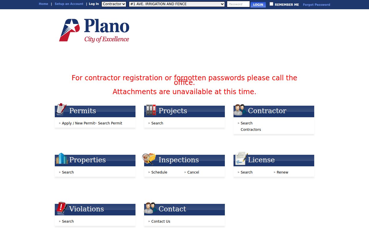
The service menu helps separate a property or permit route from a general people search. City records can also be pursued at the responsible department counter, through the city main line at 972-941-7000, or through Building Inspections at 972-941-7140 for permit questions. Exact public-terminal hours and current query filters were not established, so confirm those details before visiting.
Note: A permit may name an owner, applicant, or contractor for a dated project, not every person associated with the address.
Plano Street Directory Record Trail
An address-by-address search gains context by moving from the address to records that use different keys. CCAD supplies the parcel card. GIS supplies lot lines and boundary context. The Clerk supplies land instruments and plats. eTRAKiT may supply a dated city record. Each source should remain in its own lane, because none is a complete account of who is at a street address.
| Address record | Custodian | Useful connection | Access path |
|---|---|---|---|
| CCAD parcel card | Collin County Central Appraisal District | Owner, situs, mailing address, legal description, identifiers | Free online search, updated nightly |
| Parcel and boundary map | CCAD and Plano GIS | Parcel shape, subdivision, city context | Interactive map and public map services |
| Deed or plat index | Collin County Clerk | Parties, instrument, date, legal description | Online index, McKinney counter, mail, copies |
| City permit or property record | Plano Development Services | Site, APN, description, dates, listed project parties | eTRAKiT, department route, public-information request |
| Historical address section | Haggard, CCGS, UNT, or TSLAC | Printed prior address entries by edition | Library, scans, microfilm, or reading room |
For a known person's registration status, Texas My Voter Portal requires a name, county, date of birth, and ZIP. It is not a public all-voters-on-a-street function. Collin County's paid voter file has registered and mailing addresses, but it carries statutory use restrictions, omits phone and email data, and cannot be turned into a claim about every household. Questions about lawful access or protected records belong with Collin County Elections by its online, counter, mail, phone, or email channels.
Past Plano Addresses in Directories
The historical address layer belongs to the Plano Directory Book. Verified local examples include the 1948 Plano City Directory and Polk's 1974 directory, while a 1976 numerical page shows address-order entries. Read the scan rather than relying on OCR. The 1976 page mixes a business listing with individual entries, and OCR can join columns or misread a surname. Record the publisher, edition, page, exact street wording, and uncertainty.
Haggard Genealogy Center is the local counter route for city directories, reverse or criss-cross directories, yearbooks, newspapers, microfilm, and related CCGS materials. UNT's Portal to Texas History supplies digitized examples, while the Texas State Library and Archives Commission offers a statewide print and microform fallback in Austin. Staff should confirm any shelf run, since the precise local run and every reverse-directory year were not published in the inspected catalog pages.
If the purpose shifts from an address chain to checking a single current person, use the separate Plano resident lookup workflow. It keeps the name-based record check distinct from a street-by-street parcel trail.
Limits of a Plano Street Directory
An address search cannot establish every person at a location. Public sources can leave out guests, private utility or delivery customers, protected voters, Address Confidentiality Program participants, juvenile or victim material, and sealed records. Texas voter rules protect sensitive identifiers and permit address suppression for eligible people. The public voter lookup is person-specific, while the county file has legal use limits. Do not treat a CCAD owner, deed party, permit party, or historical directory line as a complete present-day household list.
Use the least intrusive record necessary for a lawful personal purpose. The Texas Public Information Act can request existing, non-exempt government records, but it does not compel a custodian to compile a custom street roster or answer a research question. If a valid source is unavailable online, the appropriate fallback is the clerk, city department, election office, library, archive, or written request, not an unsupported assumption.
Lawful use. Plano address records are for personal, lawful research. Do not use any record trail to stalk, harass, intimidate, or harm another person.
Note: Confirm a record with the holding office before relying on it, especially where the source names an owner, a project party, or a historical entry.